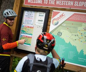
We worked closely with Shenandoah Bicycle Coalition and Massanutten Resort to create a new map for the 30+ mile SVBC-built trail network on the Western Slope of Massanutten. This project started with a simple update to an existing map and quickly grew into a complete overhaul of the map, which is now used in printed pocket map form on waterproof stock, as well as kiosk maps, ‘You are here’ on-trail maps, and a digital version.
Western Slope of Massanutten
Trail Map
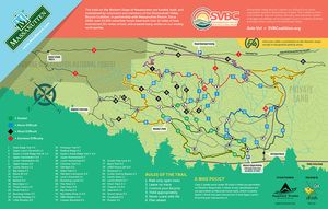

Our partnership with Dusty B Design resulted in a fun, easy to read, visually appealing map for our most popular trail system. They also branded the entire trail system with signage and markings in one complete and easily identifiable package.Kyle Lawrence — Executive Director, SVBC